

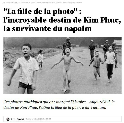
« La fille de la photo » sort du cliché
http://tempsreel.nouvelobs.com/photo/20160728.OBS
« La fille de la photo », l'incroyable destin de Kim Phuc, la survivante du napalm
article du Nouvel Obs, 28.07.2016
http://tempsreel.nouvelobs.com/photo/20160728.OBS
rappels
- Phan Thi Kim Phuc
L'enfant symbole du Vietnam
http://clioweb.free.fr/blois/kimphuc.htm
choix de liens et d'images pour un atelier multimedia de l'APHG - RDVH Blois 2007 :
Nick Ut, photo monochrome (recadrée ensuite)

vidéo (couleur) d'ITN
- Annick Cojean Retour sur images Grasset 1997
- Denise Chong La fille de la photo - Belfond 2001 - Pocket 2003
- Marc Wiese, Das mädchen und das photo, un documentaire de 2009
La petite fille brûlée au napalm - Une photo accuse 2009 - 53 mn
- les articles d'Annick Cojean,
L'enfant symbole du Vietnam, Le Monde 19.08.1997,
http://clioweb.free.fr/blois/cojean.pdf
et
« La fille de la photo » sort du cliché
M le magazine du Monde 17.06.2012
http://www.lemonde.fr/m-styles/article/2012/06/17/la-fille-de-la-photo-sort-du-cliche_1719507_4497319.html
A Toronto, 40 ans après le 8 juin 1972, Kim Phuc vit au Canada.
Elle a été nommée ambassadrice de bonne volonté pour l'UNESCO.
Elle anime la Kim Foudation International qui aide les enfants victimes de la guerre.
Elle fête les anges gardiens qui sont sans cesse apparus sur son chemin :
Nick Ut, David Burnett, Christopher Wain (ITN), Perry Kretz (Stern), etc...
« J'ai longtemps voulu fuir cette petite fille plongée dans le chaos de la guerre du Vietnam. Mais la photo m'a toujours rattrapée... j'ai décidé que ce qui m'apparaissait comme une malédiction avait aussi été ma chance. Et qu'il me revenait de choisir le sens à donner à cette photo. « Elle illustrait l'épouvante de la guerre ? Je deviendrai une ambassadrice de la paix. Elle montrait la barbarie ? Je parlerai d'amour et incarnerai le pardon. Elle évoquait la mort ? Je montrerai la vie ! »
Sur le web, il existe des sources très bien documentées :
- Horst Faas and Marianne Fulton, " The survivor, Phan Thi Kim Phuc and the photographer Nick Ut ",
un dossier mis en ligne à l’occasion d’une exposition au London Science Museum
http://digitaljournalist.org/issue0008/ng_intro.htm
- Paul Gerhard, " Die Geschichte hinter dem Foto Authentizität, Ikonisierung und Überschreibung eines Bildes aus dem Vietnamkrieg "
http://www.zeithistorische-forschungen.de/site/40208413/default.aspx
Le bombardement de 1972, la photo et ses suites :
http://clioweb.canalblog.com/tag/kimphuc
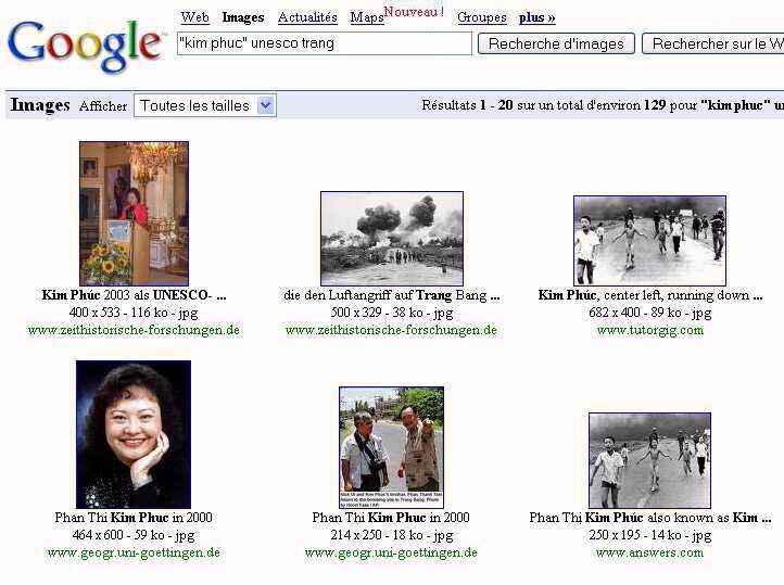
Kim Phuc, « La fille de la photo » - Google images
.


/https%3A%2F%2Fstorage.canalblog.com%2F02%2F17%2F161889%2F117651881_o.jpg)
/https%3A%2F%2Fstorage.canalblog.com%2F19%2F63%2F161889%2F117610470_o.jpg)