

Cartography in Japan 1994
Cartography in Japan
Unno Kazutaka
http://www.press.uchicago.edu/books/HOC/HOC_V2_B2/HOC_VOLUME2_Book2_chapter11.pdf
dans History of Cartography,
John Brian Harley & David Woodward,U Chicago Press 1994
(volumes disponibles en ligne en pdf, avec illustration monochrome)
http://clioweb.canalblog.com/tag/hcarto-chicago
+ chap 14,
Japanese Celestial Cartography before the Meiji Period, Kazuhiko Miyajima
extraits de la conclusion du chap 11 :
« No other civilization has preserved as many original eighth-century map documents »
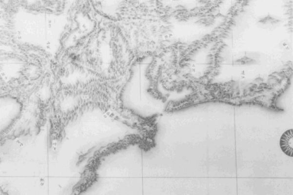
« It is in the sixteenth century that coordinated efforts were made to survey and map the provinces, beginning
in 1591 with the government of Toyotomi Hideyoshi.... Large-scale maps of 1:21,600 that covered the country from northernmost Honshu to the Ryukyus were completed in the middle of the seventeenth century.
« There was no wholesale transmission of European scientific mapping until the nineteenth and twentieth centuries.
« From the mid-eighteenth century, the influx of Dutch books, globes, and maps, the introduction of the heliocentric Copernican system, and the translation of Dutch atlases of the world and treatises on globe
making into japanese enlarged the Japanese scope of the world through Dutch eyes »
The jesuit Matteo Ricci ‘1552-1610) ' s world map was printed in several versions and became the basis of a printed map trade for maps designed to be hung in houses or published in books and encyclopedias
« A quite different tradition, that of the Buddhist world map (map of the Five Indias), was apparently current in
the seventh century (although the earliest surviving map is from the fourteenth), and survived until the mid-nineteenth century ».
« More comparative studies between the cartographies of Japan, China, and Korea need to be undertaken »
- History of maps in Japan - Wikipedia
http://en.wikipedia.org/wiki/Japanese_maps
Old maps of Japan
http://commons.wikimedia.org/wiki/Category:Old_maps_of_Japan
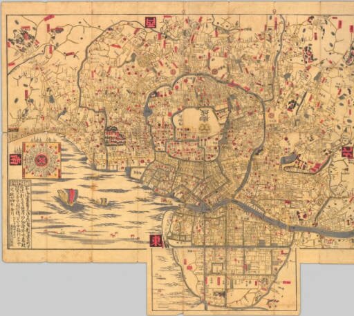
Edo 1824 - Commons
http://commons.wikimedia.org/wiki/File:Plan_of_edo.jpeg
http://open.library.ubc.ca/collections/tokugawa/items/1.0216044
..
.


/https%3A%2F%2Fassets.over-blog.com%2Ft%2Fcedistic%2Fcamera.png)
/http%3A%2F%2Fstorage.canalblog.com%2F38%2F70%2F161889%2F127522992_o.jpg)
/http%3A%2F%2Fstorage.canalblog.com%2F11%2F30%2F161889%2F125155648_o.jpg)
/https%3A%2F%2Fstorage.canalblog.com%2F02%2F17%2F161889%2F117651881_o.jpg)
/https%3A%2F%2Fstorage.canalblog.com%2F19%2F63%2F161889%2F117610470_o.jpg)