

La cartographie médiévale 1
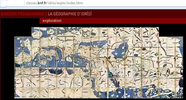
La géographie d'Idrïsi, BNF expositions
(la carte originelle est inversée, la Scandinavie est en bas)
http://classes.bnf.fr/idrisi/
La cartographie médiévale, La Fabrique de l'histoire 14.04.2016
Ecouter l'émission en différé :
http://www.franceculture.fr/emissions/la-fabrique-de-l-histoire/cartes-44-debat-historiographique-la-cartographie-medievale
Débat historiographique 4/4
avec Emmanuelle Vagnon
Cartographie et représentations de l'Orient méditerranéen en Occident : du milieu du XIIIe à la fin du XVe siècle, Brepols 2014
et Jean-Charles Ducene
L’Europe dans la cartographie arabe médiévale Belgeo 3-4 2008
http://belgeo.revues.org/8801
ajouter : Christiane de Craecker-Dussart « La cartographie médiévale : d'importantes mises au point . »
Le Moyen Age 1/2010 (Tome CXVI) - source Visionscarto
http://www.cairn.info/revue-le-moyen-age-2010-1-page-165.htm
Liens vers des auteurs cités dans l'émission La Fabrique
- Cartes et histoire, un choix de cartes et de liens :
http://clioweb.free.fr/carto/cartohist.htm
- sur l'histoire de la carto, la BNF a réalisé un travail (visuel) considérable :
Représenter la Terre, une introduction vidéo très efficace
http://expositions.bnf.fr/globes/bornes/v/21/index.htm
Les mappemondes, visions médiévales du monde
http://classes.bnf.fr/ebstorf/
. L'héritage grec : 5 zones climatiques, Claude Ptolémée (90-168)
. La géographie arabe
. La géographie chrétienne : la terre est ronde, le monde en TO, les portulans,
la redécouverte de Ptolémée (26 cartes +1) traduit du grec 1401-1406
Histoire de la cartographie
http://expositions.bnf.fr/cartes/index.htm
L'âge d'or des cartes marines
http://expositions.bnf.fr/marine/
L'atlas catalan
http://expositions.bnf.fr/marine/albums/catalan/index.htm
- De nombreux cartes sont reproduites par Wikipedia et Commons.
History of Cartography
http://en.wikipedia.org/wiki/History_of_cartography
Ancient world maps
http://en.wikipedia.org/wiki/Ancient_world_maps
dont Pietro Visconte
ou Al-Idrisi, le livre de Roger (Roger II roi normand de Sicile)
http://en.wikipedia.org/wiki/Tabula_Rogeriana
(en bas de page, une liste de cartographes arabes au M-A)
Ptolemy 's Geography
http://en.wikipedia.org/wiki/Geography_(Ptolemy)
La Fabrique du 15.11.2010 s'est intéressée au monde connu en 1510.
http://clioweb.canalblog.com/tag/1510
voir aussi les liens mentionnés dans le billet Cartes et découvertes (21.05.2015)
http://clioweb.canalblog.com/archives/2015/05/21/32092458.html
dont Martin Waldseemüller 1507
http://en.wikipedia.org/wiki/Waldseemüller_map
Piri Reis, carte de 1513 et les questions qu'elle pose
http://fr.wikipedia.org/wiki/Carte_de_Piri_Reis
http://www.uwgb.edu/dutchs/pseudosc/piriries.htm
A Blois, Boucheron et Gruzinski ont évoqué tout l'intérêt
des Ottomans pour le monde en cours d'exploration au XVIe.
- J. B. Harley and David Woodward, History of cartography University of Chicago Press
6 volumes, les 3 premiers volumes sont disponibles en pdf
http://www.geography.wisc.edu/histcart/

dont le Volume 1, Cartography in Prehistoric, Ancient, and Medieval Europe and the Mediterranean
Part 3 - Cartography in Medieval Europe and the Mediterranean
http://www.geography.wisc.edu/histcart/v1toc.html
Macrobius to Isidore: The Late Greco-Roman and Patristic Period
Bede to Lambert of Saint-Omer
Henry of Mainz to Richard of Haldingham
Pietro Vesconte to Fra Mauro: The Transitional Period to 1460
Maps of Palestine and Its Cities
Maps of Italian Cities
Cognitive Transformations
Social Contexts
rappel :
Liens vers des auteurs cités dans l'émission La Fabrique
.
.


/http%3A%2F%2Fstorage.canalblog.com%2F12%2F10%2F161889%2F130240408_o.jpg)
/http%3A%2F%2Fstorage.canalblog.com%2F58%2F95%2F161889%2F129869680_o.jpg)
/http%3A%2F%2Fstorage.canalblog.com%2F48%2F63%2F161889%2F122663268_o.jpg)
/http%3A%2F%2Fstorage.canalblog.com%2F21%2F97%2F161889%2F120783521_o.jpg)
/https%3A%2F%2Fstorage.canalblog.com%2F02%2F17%2F161889%2F117651881_o.jpg)
/https%3A%2F%2Fstorage.canalblog.com%2F19%2F63%2F161889%2F117610470_o.jpg)