

Présidentielle 2012 en cartes
- Présidentielles 2012 - Les cartes de Philippe Waniez (source : Jérôme)
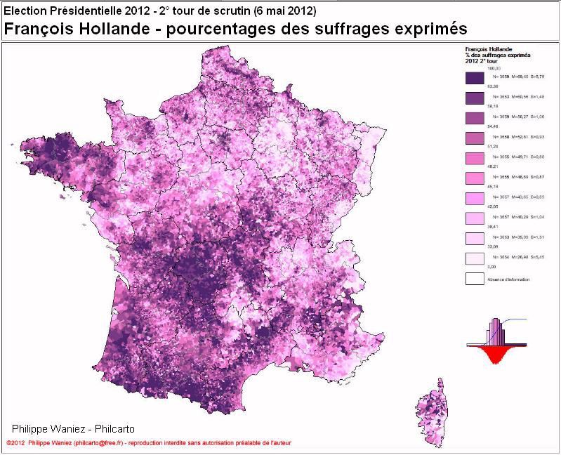
http://coucoucarto.free.fr/
http://coucoucarto.free.fr/Presid_2012_cartes_Internet/Elections_Presidentielles_France.html
- Géoclip - France O3 - L'Observatoire des votes, votes Hollande-Sarkozy
http://franceo3.geoclip.fr/index.php?profil=FV#l=fr

http://franceo3.geoclip.fr/index.php?profil=FV#i=xd_pres2012_t2.dif_hollande_sarkozy;l=fr;v=map12
- Présidentielles 2012 - Le second tour vu depuis Le Mans

France métropolitaine - « Grand ouest » - Pays de la Loire - Sarthe
ESO - Espaces et SOciétés - Le Mans
logiciel CartESO - Alain Wrobel, Sébastien Angonnet
http://eso-gregum.univ-lemans.fr/spip.php?article178
Mercredi midi, sur Canal Bernard Poignant, le maire de Quimper, soulignait le basculement à gauche de la Bretagne depuis 1981. Il aurait pu aussi rappeler l'opposition entre France de l'Ouest et du Sud-Ouest et France du Nord-Est (cf le vote en Alsace).
.


/http%3A%2F%2Fstorage.canalblog.com%2F97%2F03%2F161889%2F123916554_o.jpg)
/http%3A%2F%2Fstorage.canalblog.com%2F26%2F33%2F161889%2F118612319_o.jpg)
/http%3A%2F%2Fstorage.canalblog.com%2F43%2F02%2F161889%2F106637104_o.jpg)
/http%3A%2F%2Fstorage.canalblog.com%2F92%2F83%2F161889%2F103318365_o.jpg)
/https%3A%2F%2Fstorage.canalblog.com%2F02%2F17%2F161889%2F117651881_o.jpg)
/https%3A%2F%2Fstorage.canalblog.com%2F19%2F63%2F161889%2F117610470_o.jpg)