

Italie : carto napoléonienne
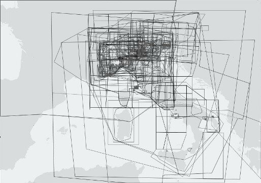
La couverture cartographique de l’Italie par le Dépôt général de la Guerre.
Dresser la cartographie napoléonienne de l’Italie : Comment et pourquoi ?
un article de Anne Godlewska
Associate Professor of Geography and Associate Dean of Arts and Science
Annales historiques de la Révolution française 320 avril-juin 2000
http://ahrf.revues.org/165
Welcome to an Atlas of Napoleonic Cartography in Italy
coopération Queen's University + Service historique de l'armée
1. Introduction
2. The Troubled History of the Survey of Italy
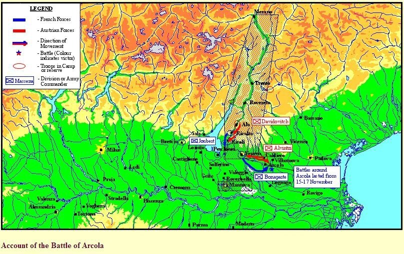
3. Cartographic Commemoration of the French Battle for Northern Italy 1796-97
4. Reconstructing a Surveyor's Work
5. A Selection of Landscape Views of the Campaigns of Napoleon in Northern Italy
6. Mapping the Island of Elba
http://web.archive.org/web/20160307165830/http://www.geog.queensu.ca/napoleonatlas/
A Military History and Atlas of the Napoleonic Wars
by Vincent J. Esposito, John R. Elting, 1999
review by Kevin Kiley
http://www.napoleon-series.org/reviews/military/c_elting.html
Napoleon and Italy: a Military History of Napoleonic Italy, 1805 – 1815
Carmigniani, Juan-Carlos and Gilles Boué
Reviewed by Robert Burnham
http://www.napoleon-series.org/reviews/c_reviewlist.html
Atlas de l'Empire napoléonien, 1799-1815
Vers une nouvelle civilisation européenne,
Jean-Luc Chappey et Bernard Gainot, Autrement 2015
http://www.autrement.com/ouvrage/atlas-de-lempire-napoleonien-1799-1815


/http%3A%2F%2Fstorage.canalblog.com%2F20%2F53%2F161889%2F130761795_o.jpg)
/http%3A%2F%2Fstorage.canalblog.com%2F15%2F39%2F161889%2F127646645_o.jpg)
/https%3A%2F%2Fassets.over-blog.com%2Ft%2Fcedistic%2Fcamera.png)
/http%3A%2F%2Fstorage.canalblog.com%2F79%2F71%2F161889%2F126742218_o.jpg)
/https%3A%2F%2Fstorage.canalblog.com%2F02%2F17%2F161889%2F117651881_o.jpg)
/https%3A%2F%2Fstorage.canalblog.com%2F19%2F63%2F161889%2F117610470_o.jpg)