

Oxford, plans anciens
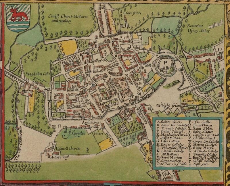
John Speed 's map of Oxford 1605
source image @HdAnchiano 20.08
(carte inversée, le Nord est en bas)
http://commons.wikimedia.org/wiki/File:John_Speed%27s_map_of_Oxford,_1605..jpg
John Speed (1552-1629)
http://en.wikipedia.org/wiki/John_Speed
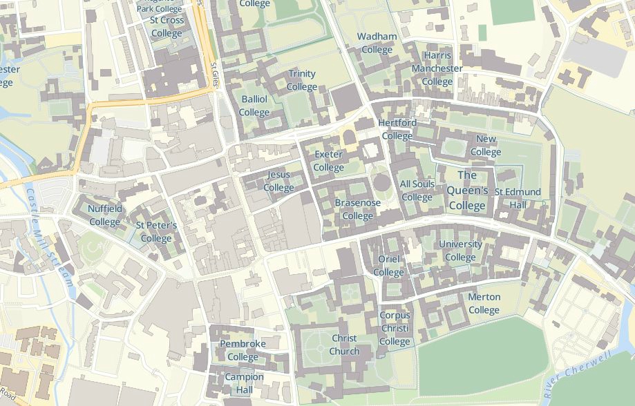
Les collèges d'Oxford aujourd'hui : http://maps.ox.ac.uk/
Les collèges d'Oxford carte et photos
http://www.planetware.com/tourist-attractions-/oxford-eng-oxf-mh.htm
Oxford
http://en.wikipedia.org/wiki/Oxford
University of Oxford
http://en.wikipedia.org/wiki/University_of_Oxford
L'article Early Modern Oxford
http://www.british-history.ac.uk/vch/oxon/vol4/pp74-180#anchorn198
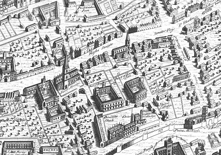
un plan de 1578 publié en 1588, regravé vers 1728
Ralph Agas (c. 1540 – 1621)
http://en.wikipedia.org/wiki/Ralph_Agas
Agas is particularly known for his large-scale town map of Oxford
John Bearblock, views of Oxford 1566 ?
Oxonia Antiqua Instaurata, Sive Urbis & Academiae Oxoniensis Topographica delineatio olim a Radulpho Agas impressa A.D. 1578
http://www.sandersofoxford.com/shop/product/oxonia-antiqua-instaurata-sive-urbis-academiae-oxoniensis-topographica-delineatio-olim-a-radulpho-agas-impressa-ad-1578-nunc-denuo-oeri-incisa-ad-mdccxxviii-huic-in-margine-acceste-cod-ms-bodl-collegiorum-scholaram-scenographia-anplior-accuratior-a-th-neal-stb-descripta-ad-1566/
Wenceslas Hollar (1607-1677) - Oxford vers 1643 ?
http://en.wikipedia.org/wiki/Siege_of_Oxford
http://en.wikipedia.org/wiki/File:Wenceslas_Hollar_-_Oxford_(State_1).jpg
un plan de 1675 par David Loggan (1634-1692)
http://en.wikipedia.org/wiki/David_Loggan
http://www.academia.edu/7717925/David_Loggans_Oxonia_Illustrata
voir aussi Oxonia Illustrata (Brasenose, Jesus, Trinity, Oriel)
http://commons.wikimedia.org/wiki/Category:Loggan's_Oxonia_Illustrata
Commons comporte davantage de reproductions pour Cambridge
"Loggan's Cantabrigia Illustrata"
http://commons.wikimedia.org/wiki/Category:Loggan's_Cantabrigia_Illustrata
Oxford 1753 - Samuel and Nathaniel Buck
http://www.pbagalleries.com/view-auctions/catalog/id/278/lot/85457/The-South-East-Prospect-of-the-University-and-City-of-Oxford
Catalogue Sanders
http://www.sandersofoxford.com/static/media/uploads/catalogues/oxford,_from_the_unusual_to_the_iconic..pdf
143 - Skelton’s reduced engraving of the Original Plan of Oxford
taken by Ralph Agas in the Year 1578
140 - [A Plan of the University and City of Oxford]
Richard Davis 1797
15 - This bird’s-eye View of the University and City of Oxford is most gratefully inscribed
by their obedient humble Servant James Ryman, c. 1848 - Nathaniel Whittock
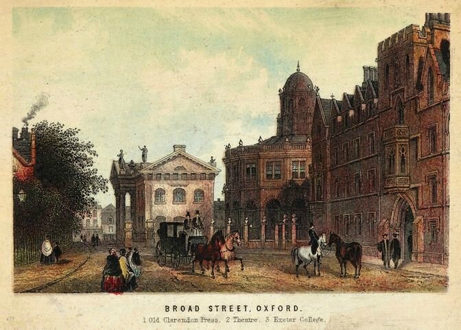
Broad Street, Oxford 1873
Illustration from Views of Oxford, published T. Nelson & Sons, 1873.
http://commons.wikimedia.org/wiki/Category:Broad_Street,_Oxford
Town plan by GW BACON. Colleges schools churches, 1883 old map
http://www.antiquemapsandprints.com/oxford-antique-town-plan-by-gw-bacon-colleges-schools-churches-1883-old-map-199121-p.asp
Old plans of Oxford - Oxford Historical Society 1883
Catalogue of maps, prints, drawings 1818, pages 251-255
http://tinyurl.com/jzr4toz
voir également
An Inventory of the Historical Monuments in the City of Oxford.
Originally published by His Majesty's Stationery Office, London, 1939.
http://www.british-history.ac.uk/rchme/oxon/plan-11
An historical map of Oxford, from medieval to Victorian Times
http://www.historictownsatlas.org.uk/content/map-historic-oxford
Oxford centre aujourd'hui, via dailyinfo.co.uk
http://www.dailyinfo.co.uk/sheet/maps/2012/central.pdf


/http%3A%2F%2Fstorage.canalblog.com%2F02%2F38%2F161889%2F130259037_o.jpg)
/http%3A%2F%2Fstorage.canalblog.com%2F10%2F43%2F161889%2F125077302_o.jpg)
/http%3A%2F%2Fstorage.canalblog.com%2F69%2F65%2F161889%2F124867389_o.jpg)
/http%3A%2F%2Fstorage.canalblog.com%2F51%2F48%2F161889%2F124674962_o.jpg)
/https%3A%2F%2Fstorage.canalblog.com%2F02%2F17%2F161889%2F117651881_o.jpg)
/https%3A%2F%2Fstorage.canalblog.com%2F19%2F63%2F161889%2F117610470_o.jpg)