

USA : How Slavery expanded 1790-1860

Map Showing the Distribution of the Slave Population of the Southern States
Edwin Hergesheimer 1861
Compiled from the Census of 1860
version Library of Congress
http://www.loc.gov/resource/g3861e.cw0013200/
reproduite par Susan Schulten, Mapping the Nation
http://mappingthenation.com/index.php/viewer/index/7
http://mappingthenation.com/
à partir de http://hdl.handle.net/10176/codu:57069
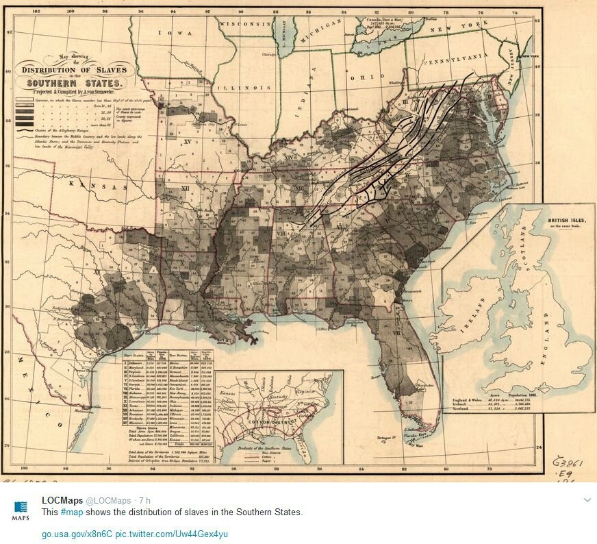
autre carte, via Twitter : distribution of slaves in the Southern States.
http://www.loc.gov/item/96685918/?loclr=twmap
A. von Steinwehr population 1860
« These Maps Reveal How Slavery Expanded Across the United States »
« As the hunger for more farmland stretched west, so too did the demand for enslaved labor »
Présentation et prolongements en animations cartographiques
par Lincoln Mullen, Smithsonian magazine - May 15, 2014 - via Twitter 07-2016
http://www.smithsonianmag.com/history/maps-reveal-slavery-expanded-across-united-states-180951452/
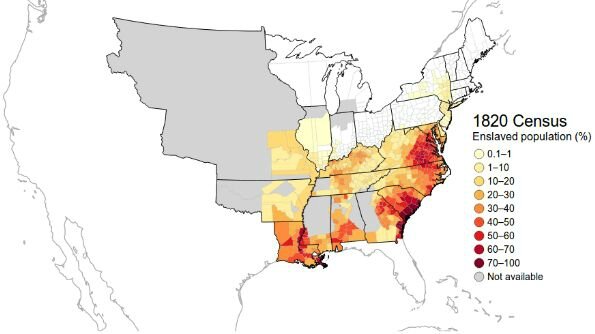
1820 Census enslaved population (%) - animation carto Lincoln Mullen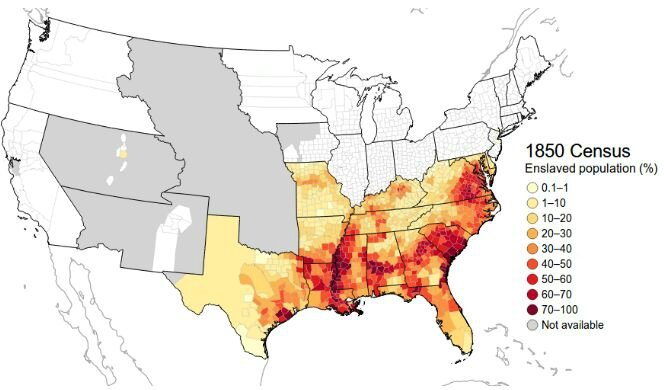
1850 Census, enslaved population (%) - animation carto Lincoln Mullen

1850 Census Free African Americans - animation carto Lincoln Mullen
US Census - Historical Census Browser
Les données des recensements de 1790 à 1960
sont en ligne sur un site de l'université de Virginie (Library)
http://mapserver.lib.virginia.edu/
Voir aussi les cartes de l'Atlas des esclavages, B. Gainot & M. Dorigny, ed Autrement
http://clioweb.canalblog.com/archives/2014/01/21/28998814.html
http://clioweb.free.fr/dossiers/colonisation/atlas-esclavages.htm
rappel : http://clioweb.canalblog.com/tag/slaves1860


/http%3A%2F%2Fstorage.canalblog.com%2F63%2F19%2F161889%2F129075677_o.jpg)
/http%3A%2F%2Fstorage.canalblog.com%2F38%2F45%2F161889%2F128476505_o.jpg)
/http%3A%2F%2Fstorage.canalblog.com%2F71%2F58%2F161889%2F128390071_o.jpg)
/http%3A%2F%2Fstorage.canalblog.com%2F38%2F70%2F161889%2F127522992_o.jpg)
/https%3A%2F%2Fstorage.canalblog.com%2F02%2F17%2F161889%2F117651881_o.jpg)
/https%3A%2F%2Fstorage.canalblog.com%2F19%2F63%2F161889%2F117610470_o.jpg)