

USA Population change
Plusieurs cartes repérables à partir de Google
en tapant
usa "population change" 2000 to 2010 county map
à la ligne, il est possible d'ajouter census.gov ou censuscope
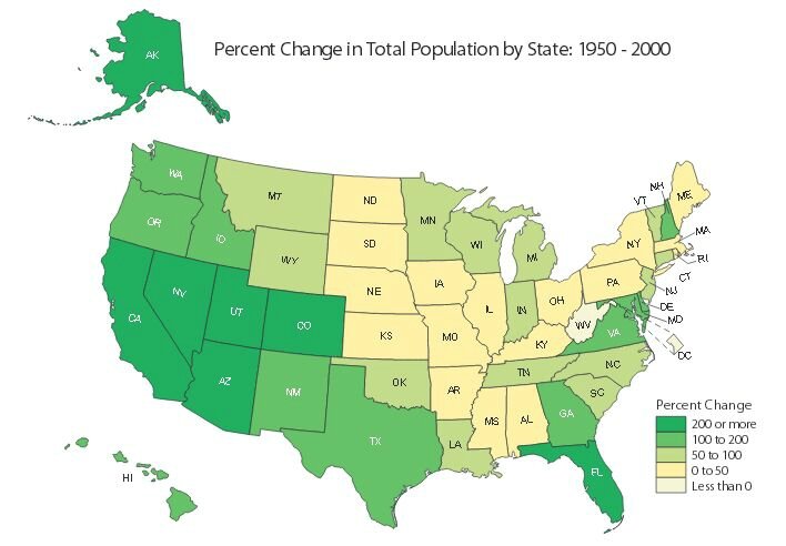
http://www2.census.gov/geo/pdfs/maps-data/maps/thematic/pctchangein_tot_pop1950_2000.pdf
Census.gov, dans Thematic Maps
http://www.census.gov/geo/maps-data/maps/thematic.html
Une entrée Population change avec des chiffres 1930, 1950, 2000...
Census Scope - 1990-2000
http://www.censusscope.org/us/map_popchange_90-00.html
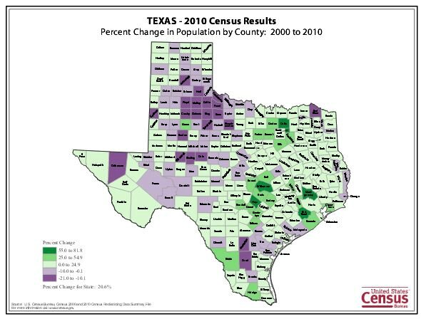
Census.gov, par Etat, 2000-2010 variation par comté pour le Texas
http://www2.census.gov/geo/pdfs/maps-data/maps/2010pop/tx_perchange_2010map.pdf
Maps Visualize U.S. Population Growth by County 2000-2010
http://www.texastribune.org/2011/03/25/maps-visualize-us-population-growth-by-county/

USDA (agriculture)
population Change par comtés, 2003-2007, 2010-2014
http://tinyurl.com/joflrud
http://www.ers.usda.gov/topics/rural-economy-population/population-migration/shifting-geography-of-population-change.aspx
Change in population 2000-2010
http://projects.nytimes.com/census/2010/map
Par états 2010-2014
http://nation.maps.arcgis.com/apps/SimpleViewer/index.html?appid=a6cb3e1caa7549418b1a5945bcb36717
http://nation.maps.arcgis.com/apps/SimpleViewer/index.html?appid=a6cb3e1caa7549418b1a5945bcb36717
http://www.arcgis.com/home/webmap/viewer.html?webmap=0a27f5cb1f07478fbdf117b70231c5c2
.
.


/https%3A%2F%2Fstorage.canalblog.com%2F02%2F17%2F161889%2F117651881_o.jpg)
/https%3A%2F%2Fstorage.canalblog.com%2F19%2F63%2F161889%2F117610470_o.jpg)