

Watsonville - Pajaro Valley
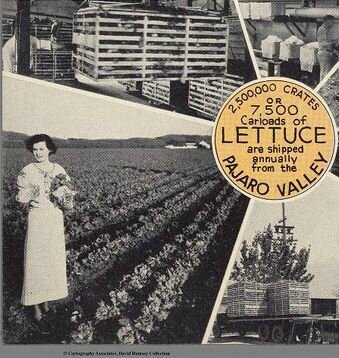
Pajaro Valley, laitues et robe ultra-longue - 1945 ? - (détail)
The Fertile Pajaro Valley is the Heart of Historic Monterey Bay Region
Splendid highways, Excellent schools, fin churches, cheap water...
promotion du territoire par une double page de la Chambre de commerce locale
source David Rumsey Collection

Pajaro Valley 1945, Miles of Silver Beaches et jambes levées - détail en haut de la page suivante :

La source : Live, Work and Play in the beautiful Pajaro Valley
promotion en photos et en texte.
David Rumsey collection

Watsonville, 150 km au sud de San Francisco
sur la carte Google Maps : Sunset State Beach, Manresa State Beach...

Sud-Ouest de Watsonville, photo aérienne, Commons - date non précisée
http://images.usace.army.mil/images/Hires/Cespn-05.Jpg
http://commons.wikimedia.org/wiki/Category:Watsonville,_California

Sud-Ouest de Watsonville, Google maps

Watsonville, Google maps
.


/http%3A%2F%2Fstorage.canalblog.com%2F82%2F89%2F161889%2F125001553_o.jpg)
/http%3A%2F%2Fstorage.canalblog.com%2F49%2F36%2F161889%2F88629753_o.jpg)
/https%3A%2F%2Fassets.over-blog.com%2Ft%2Fcedistic%2Fcamera.png)
/http%3A%2F%2Fstorage.canalblog.com%2F30%2F92%2F161889%2F105567233_o.jpg)
/https%3A%2F%2Fstorage.canalblog.com%2F02%2F17%2F161889%2F117651881_o.jpg)
/https%3A%2F%2Fstorage.canalblog.com%2F19%2F63%2F161889%2F117610470_o.jpg)